Luke Skywalker
Super Moderator
{vb:raw ozzmodz_postquote}:
Get the news
Log In or Subscribe to skip
3 [h=6]Share This Story![/h]Let friends in your social network know what you are reading about
[h=4]All eyes on Joaquin as storm strengthens to Category 3 hurricane[/h]Mid-Atlantic braces for possible landfall storm as sustained winds hit 125 mph
{# #}
[h=4]Sent![/h]A link has been sent to your friend's email address.
[h=4]Posted![/h]A link has been posted to your Facebook feed.
[h=6]Join the Nation's Conversation[/h]To find out more about Facebook commenting please read the Conversation Guidelines and FAQs
[h=2]UP NEXT[/h][h=2]03[/h]
Forecasters at the National Hurricane Center expect that Hurricane Joaquin will strengthen to a Category 4 storm by early Friday morning.
The National Oceanic and Atmospheric Administration on Oct. 1, 2015, distributed a satellite image acquired by GOES East of Hurricane Joaquin in the Western Atlantic Ocean.(Photo: NOAA, EPA)
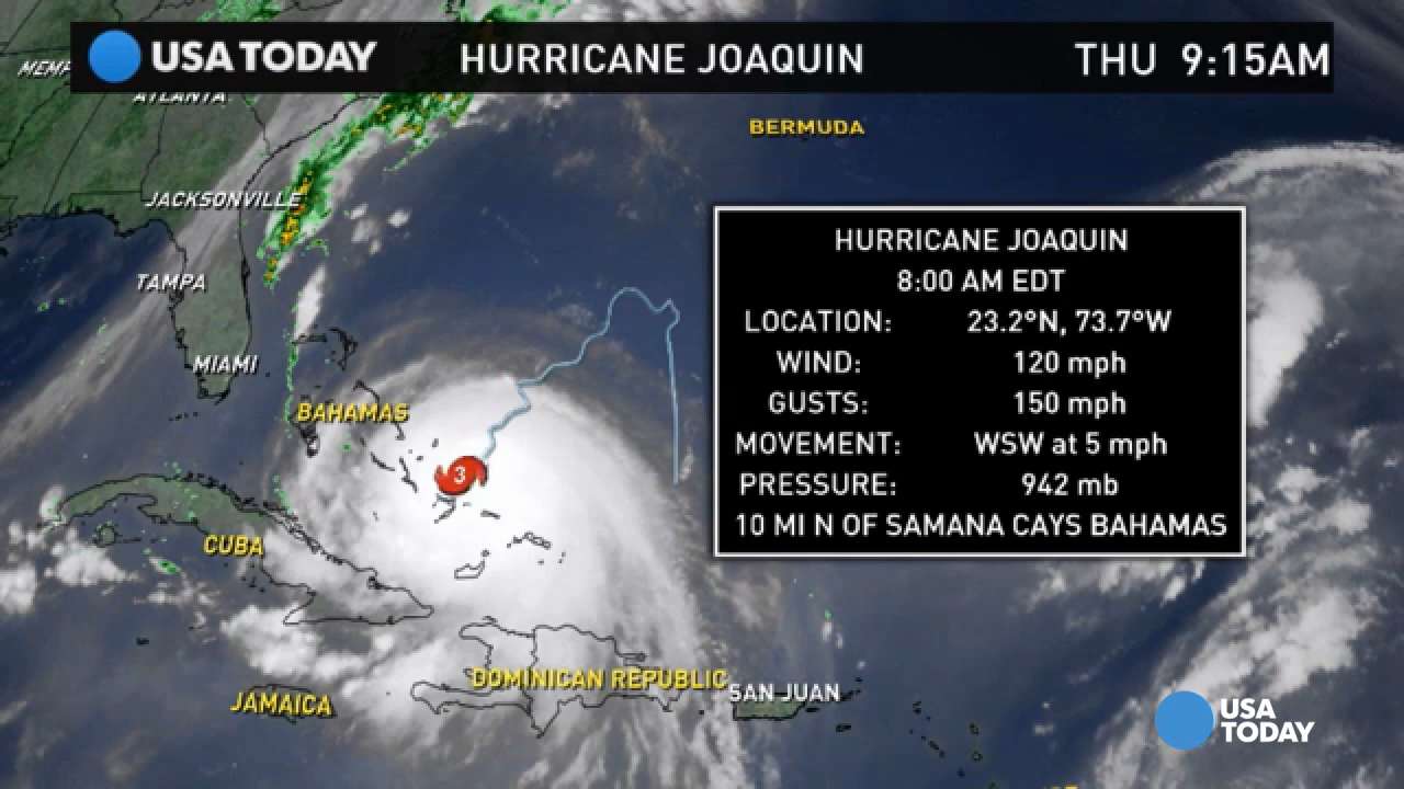
Hurricane Joaquin, already a Category 3 storm, continued to strengthen Thursday as it churned<span style="color: Red;">*</span>through the Bahamas. Forecasters are still uncertain whether it will make a weekend landfall<span style="color: Red;">*</span>along the<span style="color: Red;">*</span>East Coast.
The storm, with maximum sustained winds increasing at midmorning to 125<span style="color: Red;">*</span>mph, was lashing the central<span style="color: Red;">*</span>Bahamas<span style="color: Red;">*</span>with hurricane strength winds that extended<span style="color: Red;">*</span>as far as 35 miles from the eye,<span style="color: Red;">*</span>the National Hurricane Center in Miami reported.
As of 11<span style="color: Red;">*</span>a.m. EDT, the center of the storm was passing over<span style="color: Red;">*</span>Samana Cays, Bahamas, and moving southwest at 6<span style="color: Red;">*</span>mph. It is forecast to turn toward the west-northwest Thursday night followed by a turn toward the north and an increase in forward speed Friday, according to the hurricane center.
Joaquin is expected to produce total rain accumulations of 10 to 15 inches over the central Bahamas;<span style="color: Red;">*</span>isolated maximum
amounts of 20 inches are possible. The Bahamas Department of Meteorology warned of the possibility of life-threatening flash floods and surf<span style="color: Red;">*</span>and dangerous<span style="color: Red;">*</span>rip currents, The Bahamas Press reports.
Forecasters remain<span style="color: Red;">*</span>divided on whether Joaquin will touch land along the East Coast, but it is expected to strengthen into a Category 4 storm late Thursday, according to AccuWeather.com.
The National Hurricane Center's long-term forecast showed the storm could graze the East Coast along North Carolina and Virginia on Sunday. It advised that a hurricane watch for a portion of the U.S. coast could be required as early as Thursday night.
"Residents of the Carolinas north should be paying attention and monitoring the storm. There's no question," Eric Blake, a hurricane specialist with the center, told<span style="color: Red;">*</span>the Associated Press. "If your hurricane plans got a little dusty because of the light hurricane season, now is a good time to update them."
[h=2]UP NEXT[/h][h=2]03[/h]
Hurricane Joaquin is expected to pass over parts of the Bahamas on Thursday. The storm could hit the U.S. over the weekend, adding more rain after recent East Coast downpours. (Oct. 1) AP
Ahead of the storm, heavy rains were already soaking much of the eastern U.S. from a stalled front, the National Weather Service said. The rains "are likely to continue for the next few days, even if the center of Joaquin stays offshore," a weather service report said.
"The resulting inland flood potential could complicate preparations for Joaquin should it head toward the coast, and even more substantial inland flooding is possible," the weather service said. Flood watches have been posted in the Carolinas and in Virginia.
Joaquin<span style="color: Red;">*</span>was forecast to turn to the north and northwest late Thursday or Friday, but forecasters were still gathering data to determine how it might affect the U.S. At least two computer models showed the storm heading north without reaching the U.S. mainland.
USA TODAY
Hurricane Joaquin scatters cruise ships in the Bahamas
"We've got Air Force reconnaissance planes continuously giving us data from inside the hurricane this morning, and we're going to be throwing a lot more aircraft resources at this problem over the next few days because it still is not certain whether or not Joaquin will directly impact the U.S. East Coast or stay out to sea," said Rick Knabb, director of the National Hurricane Center.
"Because landfall, if it occurs, is still more than three days away, it is too early to talk about specific wind, rain<span style="color: Red;">*</span>or surge impacts from Joaquin in the United States," the hurricane center said Wednesday.
Regardless of Joaquin's<span style="color: Red;">*</span>track, strong onshore winds will create minor to moderate coastal<span style="color: Red;">*</span>flooding along the coasts of the Mid-Atlantic and northeastern<span style="color: Red;">*</span>states through the weekend, the hurricane center said.
States along the East Coast are bracing for the worst.
In Virginia, Gov. Terry McAuliffe declared a state of emergency Wednesday<span style="color: Red;">*</span>because of the predicted heavy rain event Thursday and Friday and the potential weekend hurricane.
On Thursday morning,<span style="color: Red;">*</span>New Jersey Governor Chris Christie also declared a state of emergency for his state.
Brian Fortier, senior meteorologist at the Weather Channel, warned, "It could be a significant situation. Everyone along the Northeast coast, right up to New England, should keep a close eye on the forecasts."
President Obama was briefed about federal preparations for Joaquin in case it hits the East Coast, White House spokesman Josh Earnest said Wednesday.
0) { %> 0) { %>
0) { %>
Powered By WizardRSS.com | Full Text RSS Feed
